University Appointments
2020/09 - present, Associate Professor, Department of Geography and Environmental Studies, Texas State University, TX, USA
2014/08 - present, Faculty Scholar, Texas Center for Geographic Information Science, Texas State University, TX, USA
2014/08 - 2020/08, Assistant Professor, Department of Geography, Texas State University, TX, USA
2012/04-2013/12, Visiting Researcher (Academic Guest) , Institute of Cartography and Geoinformation, ETH Zurich, Switzerland
(Selected) Research Projects
- Advancing Spatial Analytical Methods through the Integration of Explainable Machine Learning (in progress)
This project is funded by the Texas State College of Liberal Arts Seed Grant (PI: Y.Yuan). The primary goal of this research is to significantly refine and enhance the precision and interpretability of spatial analysis techniques, which are central to advancing geographical studies. Before applying for an external grant, we plan to conduct a pilot study that uses a new approach by combining explainable machine learning technologies with a well-established method known as Geographically Weighted Regression.
- Modeling the Changes in Urban Mobility Patterns during COVID-19 (in progress)
This project is funded by the Texas State Center for Analytics and Data Science (PI: Y.Yuan, Co-PI: F.Wang). The goal is to investigate the alterations in urban mobility patterns that occurred during the COVID-19 pandemic. The primary objective is to comprehensively understand the shifts in mobility patterns in response to government-imposed "shelter-in-place" orders, a crucial aspect of the pandemic response. Moreover, the project aims to explore the correlation between these mobility changes and various demographic factors. To achieve these objectives, the research employs advanced analytical techniques such as dynamic time warping and hierarchical clustering to analyze travel distances and patterns using mobile device data. By conducting a comparative analysis of mobility patterns before and during the pandemic, this project aims to provide valuable insights and data-driven recommendations for urban planners and policymakers.
- Can Hotspot Policing Reduce Emergency Response Times while Preventing Crime? Using Data Science to Improve the Effectiveness of Directed Police Patrol (in progress)
This project is funded by the Texas State Center for Analytics and Data Science (PI: L.Summers, Co-PI: Y.Yuan). Studies aiming to detect and predict crime hotspots do so with one of two main goals: 1) to minimize response times when dispatching emergency calls; or 2) to allocate patrol so that its presence deters offending. To date, these two literature bodies have remained largely independent from each other. However, from a practical perspective, it would be advantageous to develop a patrol prioritization model that accomplishes both objectives. The current study applies data science methods to compare the spatial and temporal distributions of high-visibility crime and high-priority calls for service (CFS), thus laying the foundations for this research. We will use one year’s worth of data from San Marcos Police Department in Texas for: 1) all priority 1 CFS (requiring immediate assistance); and 2) reports for high-visibility crime to include all vehicle crime and burglary, robberies in commercial/outdoor locations, and other outdoor property and violent offenses (i.e., amenable to be deterred by police patrol, based on offense and location type). It is hoped this research program will help develop police patrol allocation strategies that will reduce crime and improve law enforcement response.
- Developing a Web Mapping System for Election Precinct Search (completed)
Comal County is located in the state of Texas and is home to more than 150,000 residents. With an increasing population, the County faces significant challenges when organizing and conducting elections. One of the most significant challenges is providing voters with up-to-date information, such as the correct precinct, school district an address belongs to.
This project, funded by a non-profit organization in the Comal County, aims to create a web mapping system for election precinct information (PI: Y.Yuan, Co-PI: J.Jensen). This system would be a modern and user-friendly platform that would provide significant benefits for Comal County voters. By providing easy access to election information, the system would help to increase voter participation and ensure that all residents have an equal opportunity to exercise their right to vote.- Evaluating the effectiveness of location-based social media in human activity modeling (completed)
Recent studies have investigated the use of location-based social media (LBSM) to generalize, model and predict human mobility. However, LBSM data suffer from different levels of data quality issues (such as accuracy, precision, scale, and sampling bias) across population groups. The representativeness and reliability of LBSM data and its influence on the quality of derived human mobility (i.e., inference accuracy) have not been systematically investigated. Answers to these questions are fundamental to the proper use of such data for human mobility related decision making. Given the need to evaluate the efficacy of LBSM data in modeling human mobility, this research proposes to examine the sampling biases of LBSM data and its reliability to support deriving human mobility patterns at both individual and aggregated levels, as different analytical scales may reveal distinct patterns. The evaluation of population bias of LBSM data fills the research gap on the representativeness of LBSM data in human mobility modeling, which has been a continuing challenge in data mining.
Figure 1. Approximating LBSM activity space based on different indicators.
- Exploring inter-country connection in mass media (completed)
The development of theories and techniques for big data analytics offers tremendous possibility for investigating large-scale events and patterns that emerge over space and time. In this research, we used a unique open dataset “The Global Data on Events, Location and Tone” (GDELT) to model the image of China in mass media, specifically, how China has related to the rest of the world and how this connection has evolved upon time. We examined and compared the distance decay effect in mass media, social media, and public transportation data. This study generated valuable input regarding the interpretation of the diplomatic and regional correlation for the nation of China. It also provides methodological references for investigating international relations in other countries and regions in the big data era.
Figure 2. Top 15 countries with the closest connection with China in GDELT dataset
- Characterizing human mobility from mobile phone usage (completed)
This project was funded by the Swiss national science foundation (SNSF) (PI: M.Raubal) and the U.S. Department of Transportation (PI: M.Raubal, Co-PI: Y.Yuan).
Our mobile information society depends increasingly on the use of Information and Communication Technologies (ICTs) such as mobile phones. People’s usage of these technologies impacts many aspects of their lives, but the relationship between ICTs and human activities is not fully known. A better understanding of this relationship will help in predicting people’s mobility patterns and provide important guidelines for maintaining sustainable transportation, updating environmental policies, and designing early warning and emergency response systems. The goal of this project is to develop a framework for extracting and characterizing human mobility patterns from georeferenced mobile phone datasets. We analyzed different types of information that can be stored in mobile phone datasets, and developed human mobility models and data mining methodologies for spatio-temporal knowledge discovery. These models provide the basis for investigating and quantifying the relationship between human physical travel, communication travel, and environmental structure. This research also addressed issues of uncertainty, which may arise from the natural variability of human mobility, the inaccuracy and imprecision of recorded trajectories, and the imperfection of the underlying models. The results advance conventional geographic knowledge discovery by focusing on knowledge extraction from sparse datasets with low resolution and individual attributes. The case study from northeast China allows us to examine the influence of mobile phone usage in a highly populated and rapidly developing country.


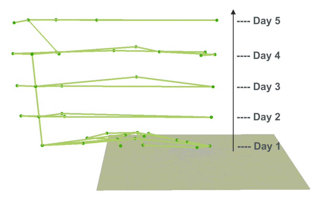
Figure 3. Trajectory of an example user
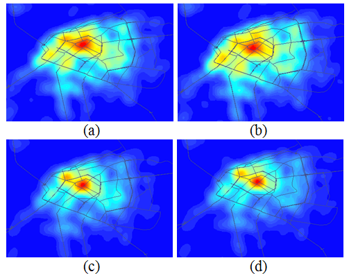
Figure 4. Mobility patterns at different time of a day
- Context-based place name searching system (completed)
With the development of the World Wide Web (WWW), unstructured or semi-structured documents that contain place names are considered an important source for retrieving geographical information. This project (funded by the Chinese National Science Foundation, PI: Y. Liu) designed a geographical knowledge-informed digital gazetteer service, KIDGS, which provides a standard web service that enables XML-based interfaces for various applications. Previous digital gazetteer systems are mostly implemented based on relational databases; however, it is important to consider geographical knowledge, such as categories and relation information when conducting queries in a gazetteer service. To this end, KIDGS adopts OWL(Protégé) and PostGIS to conceptualize and incorporate geographic knowledge into a new place name searching system.
Figure 5. The framework of KIDGS